The Wikitude development team has just released an update to ourUnity plugin!
Being Wikitude’s #1 plugin since its first release, this upgrade adds a number of cool features to our native SDK, including the long-awaited 3D tracking and a new sample app!
So here it is, the new Unity plugin 1.2.1-1.1.0 (read: Plugin version 1.1.0 including Wikitude SDK 1.2.1) is now available for download and free trial to our developer community!
What’s new?
Upgrade to Wikitude SDK (Native API) 1.2.1
3D Tracking
Extended Tracking quality indicator
Camera Controls (back/front camera)
Callbacks are now Unity Events
New Unity Plugin Reference included
Improved and extended documentation
New Unity based sample app for Android and iOS
Several bug fixes and stability improvements
Note that due to the changes the upgrade requires some migration steps to be followed. A step-by-step migration guide is available to upgrade your Unity-based apps!
The update is free for all existing Unity Plugin users and available for Android and iOS apps.
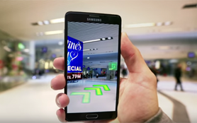
As part of our mission to keep augmenting the world around us, our tech team has been extending the capabilities of our 3D tracking. We started simple with the first public beta version of this feature a few months back, recognizing and tracking small-scale spaces. As things progress very quickly, Wikitude’s computer vision team is taking a step forward to track and map bigger environments or “large-scale” scenes as we like to call it.
In this post we will provide an insight on Wikitude’s 3D tracking technology, share our next move on the 3D tracking road and provide a hands on demo of our large scale feature, the WikiWings app for Android.
The Wikitude cross-platform 3D Tracking technology
Tracking objects and environments in 3D is a complex task. Particularly if this is done without depth sensors and by using just a single front facing the camera as found in the majority of smartphones out there today. We, humans, are actually at an advantage as we are equipped with two eyes (cameras) for sensing depth and understanding the third dimension.
The Wikitude team has been working tirelessly in the past three years with the aim to create a common base for recognizing and tracking three-dimensional objects, structures, and spaces. The market requirements range from being able to recognize objects of a few centimeters in size up to positioning a device in a sequence of rooms and corridors stretching several 100s of meters. There is no “one” computer vision algorithm out there that can support this broad set of requirements and use cases – yet. As the pioneer in the mobile augmented reality industry with a razor sharp focus on technology only, we will continue to address the demand for varying “flavours” of 3D recognition and tracking. The result of this approach is a strong common core for 3D tracking, which serves as the common base for a number of use cases.
The Wikitude 3D Tracking engine
In the past weeks, another building block of our 3D tracking has evolved, and today we are excited to share with you the second part of our journey to map and track the world around us.
From “small-scale” to “large-scale”
Wikitude’s first 3D tracking beta released a couple of months ago was the initial public release for mapping and tracking objects and environments on a small scale, such as an office desk for example, as previously described in our blog. We have gathered feedback from our developer community in the past weeks and worked on an updated version of our small-scale 3D tracking. Interested developers can request our updated (December 1st, 2015) version of the beta on our 3D tracking page feature page.
As a next step, we are preparing our next public releases for tracking and mapping larger indoor spaces to navigate users, display augmentations in rooms or show points of interest inside buildings.
To demonstrate the basics of our large scale 3D tracking feature already, our development team took the Wikitude office as an initial test environment. The video below is a first hands-on example of the current capabilities of our SLAM based 3D tracking applied to indoor navigation and localization.
The first step of the above demo is to identify objects and physical structures of the room that will provide key feature points to be tracked. As the user moves around, feature points are captured and become the base for the forming map on the device, see the box in the bottom right corner on the device in the video above. Once the algorithm has tracked key features of our office, it’s time to augment the scene! In the technical demo, we demonstrate a simple augmentation of an animated 3D model using our Native iOS SDK.
Large scale in action: use cases with the Wikitude 3D tracking
The demand for technology that “understands” and enhances the larger spaces around us inside of shopping malls, public buildings, airports, train stations etc. is tremendous. Often times we wonder what’s the shortest way to a departure gate inside of airports and train stations, where we can get the best deals in large shopping malls or find the nearest Starbucks, or locate a piece of machinery on complex industrial sites, even indoor gaming is frequently being requested for. Here are some of the many use cases where the Wikitude 3D tracking can be applied.
Gaming
One of the coolest applications of our large scale 3D tracking is the ability to make rooms highly interactive. This feature allows users to hunt for flying dragons in your living room, fight living creatures in your kitchen or follow an alien in a shopping mall. Any room can become the scene of your game!
Architecture
What if we could see a design idea of a building structure in real time? Or plan industrial spaces before a single brick is being moved? Architects can use Wikitude’s large scale 3D tracking to display their plans on their client’s tablet, helping them easily visualise what things will look like upon completion of the project.
Indoor navigation (proof of concept)
Tracking and mapping indoor spaces enables powerful indoor navigation. Locating deals in the maze of big shopping centers, leading passengers to their boarding gates inside of airports are only the beginning.
Check out WikiWings, Wikitude’s large-scale demo app
The Wikitude large-scale capabilities will be available in our SDK soon, however, you can get an early taste of it already by downloading the WikiWings demo app for Android.
(We have already shot quite a number of dragons at our office ;)
Update (August 2017): Start developing with Wikitude SDK 7
Getting started with SDK 7 has never been easier! Here’s how:
Download SDK 7 and sample app (included in the download package)
2020 Update: Wikitude SDK now supports 3D tracking, Object tracking and 3D Model as input method (CAD). Learn more.
With this post, we are opening a new chapter on Wikitude’s journey towards augmenting the world! We are happy to share today the first version of the all new Wikitude 3D tracking technology. For our team, augmenting rooms, spaces, and objects around us is a natural progress after mastering augmentations on 2D surfaces. Clearly, tracking in 3D is a much more complex task as algorithms must be optimized for a variety of use cases and different conditions. With this release of our 3D tracking technology, developers will be able to map areas and objects of a rather small scale and place 3D content into the scene.
This is the first step of a sequence of releases Wikitude will roll out as our SLAM based 3D recognition and tracking technology evolves. The 3D tracking (instant tracking) feature is now available as a free trial and packaged in our SDK PRO products. This feature is currently available for the SDK 5 Native APIs only.
How does Wikitude 3D tracking work?
The Wikitude SDK tracks 3D scenes by identifying feature points of objects and environments. By identifying feature-rich environments, the SDK will map the scene by displaying a point cloud over the different feature points.
As an example of how the Wikitude 3D tracking works in a small scene, we will use the scenario of an office table. The richer the scene is equipped with feature points, the better the mapping and tracking will be.
In order to track and map the scene the following steps should be taken:
Launch the Wikitude sample app, which is included in the Native SDK (iOS and Android) download package
Record a tracking map by slowly moving the device from one side to the other of the scene, covering the whole area
3D point clouds will appear on the screen capturing key feature points of the scenario
Save the tracking map
Load the map in your augmented reality experience to relocalize the scene and visualize the augmentation in real time.
Important note: It is not possible to use both 2D and 3D tracking within one experience. If you use 3D tracking, recognition, and tracking of 2D markers will not be launched.
Developers can now try the Wikitude 3D tracking together with the SDK 5 free trial. A trial key that has been generated on Oct 15 2015 or later is required. License keys prior to that will show a warning Unlicensed feature when you try to use 3D tracking. If you generated a license key earlier than October 15th, just revisit the license page and a new key will be automatically generated.
The Wikitude 3D Tracking is included in the Native SDK download packages for iOS and Android. In our documentation section you can find all details of this new cross-platform technology and follow the step-by-step set up guide to get started (Android, iOS). We can’t wait to get your feedback and are happy to answer questions you have at sales@wikitude.com or in our developer forum.
And before we close this post, here is a sneak peek of what is coming next! Subscribe to our newsletter and stay tuned to our developments on our dedicated SLAM page.
Update 2017: 3D Instant Tracking now available for Multiple Platforms and Development Frameworks
The Wikitude SDK is available for both Android and iOS devices, as well as a number of leading augmented reality smart glasses.
Developers can choose from a wide selection of AR development frameworks, including Native API, JavaScript API or any of the supported extensions and plugins available.
Among the extensions based on Wikitude’s JavaScript API are Cordova (PhoneGap), Xamarin and Titanium. These extensions include the same features available in the JS API, such as location-based AR, image recognition and tracking and SLAM. Unity is the sole plugin based on the Wikitude Native SDK and includes image recognition and tracking, SLAM, as well as a plugin API, which allows you to connect the Wikitude SDK to third-party libraries.
 Support
 FAQ
FAQ